 EMODnet Product Catalogue
EMODnet Bathymetry Consortium
Type of resources
Available actions
Topics
Keywords
Contact for the resource
Provided by
Formats
Representation types
Resolution
-
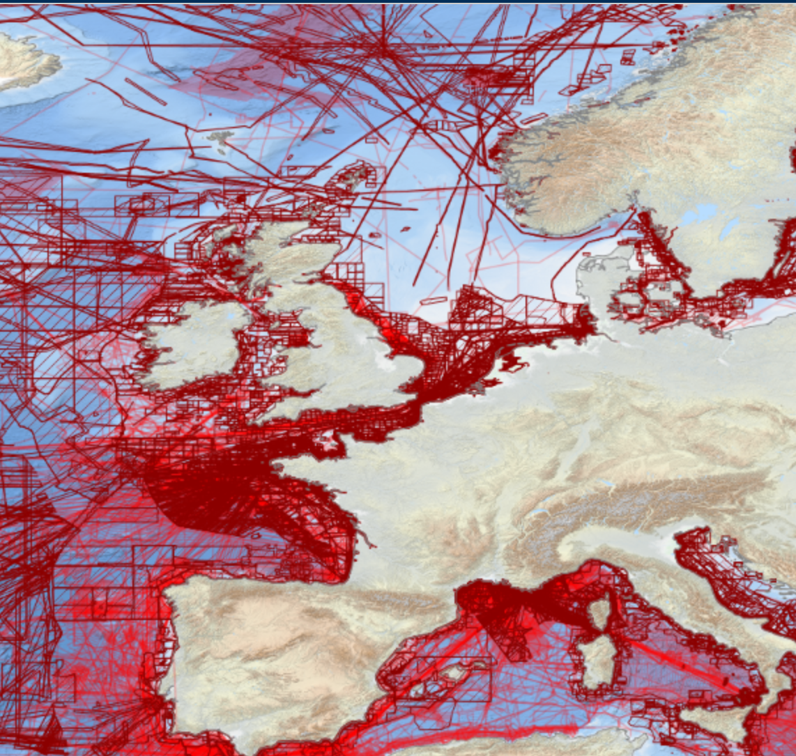
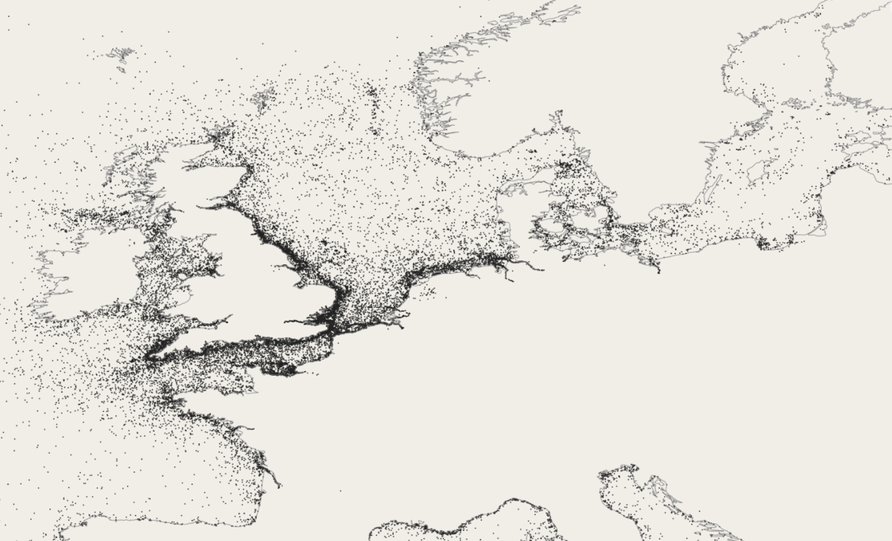
EMODnet Bathymetry has adopted the CDI Data Discovery & Access service as developed and operated by SeaDataNet, the pan-European network of NODCs, to bring together and provide access to available high resolution bathymetric survey data sets from many data providers, such as National Hydrographic Institutes, Research Institutes, and Survey companies. All bathymetric survey data are described with INSPIRE compliant metadata, following the CDI metadata profile, based on ISO 19115 – 19139 standards. This way, the CDI service gives users a highly detailed insight in the availability and geographical spreading of bathymetric survey data sets that are acquired and managed by an increasing group of data providers and for which users can request access for downloading. The CDI metadata are public domain and freely available for all users. However, a major part of the survey data sets is not freely available and requires negotiation with the data owners. The SeaDataNet CDI search, shopping and tracking mechanism facilitates identifying and requesting access to these background data sets from data providers. Note that all data sets are used internally with permission of the data owners for contributing to the EMODnet Digital Terrain Model (DTM) for the European sea regions. The service URL is : https://geo-service.maris.nl/emodnet_bathymetry/wfs?service=WFS&request=GetCapabilities. The layer in the Map Viewer facilitates users to view the locations of the CDI entries and to retrieve details of individual surveys by clicking on the map. From there users are linked to the actual CDI Data Discovery and Access service (https://cdi-bathymetry.seadatanet.org/search) for performing more queries and submitting requests for data access.
-
The EMODnet Bathymetry Ship Wreck data service is a WMS service that provides a styled representation of know Sunken ships and other disused man-made objects in EMODnet waters. The WMS service is provided by the UK company Oceanwise Ltd. The service is restricted and can only be accessed in the EMODnet data portal.
-
OpenStreetMap (OSM) is a collaborative project to create a free editable geographic database of the world. The geodata underlying the maps is considered the primary output of the OSM project. The creation and growth of OSM has been motivated by restrictions on use or availability of map data across much of the world, and the advent of inexpensive portable satellite navigation devices. EMODnet bathymetry considers OSM to be the best source for land data to complement the marine environment and to allow easier navigation in the data portal. OpenStreetMap is a free and noncommercial project; everyone can just download OpenStreetMap data free of charge and process it. However EMODnet Bathymetry requires a tailored rendering of OpenStreetMap data as in all standard available visualisations the world oceans are obscured by water features which have no use in a marine environment. In addition, EMODnet requires a non-projected rendering with no land use which is not the OSM render default. The OSM rendering is provided to EMODnet by the German company Geofabrik (www.geofabrik.de).
-

The "EMODnet Digital Bathymetry (DTM)- 2022" is a multilayer bathymetric product for Europe’s sea basins covering: • the Greater North Sea, including the Kattegat and stretches of water such as Fair Isle, Cromarty, Forth, Forties,Dover, Wight, and Portland • the English Channel and Celtic Seas • Western Mediterranean, the Ionian Sea and the Central Mediterranean Sea • Iberian Coast and Bay of Biscay (Atlantic Ocean) • Adriatic Sea (Mediterranean) • Aegean - Levantine Sea (Mediterranean). • Madeira and Azores (Macaronesia) • Baltic Sea • Black Sea • Norwegian and Icelandic Seas • Canary Islands (Macaronesia) • Arctic region and Barentz Sea The DTM is based upon 21937 bathymetric survey data sets and Composite DTMs that have been gathered from 64 data providers from 28 countries riparian to European seas and beyond. Also Satellite Derived Bathymetry data products have been included fro Landsat 8 and Sentinel satellite images. Areas not covered by observations are completed by integrating GEBCO 2022 and IBCAO V4. The source reference layer in the portal viewing service gives metadata of the data sets used with their data providers; the metadata also acknowledges the data originators. The incorporated survey data sets itself can be discovered and requested for access through the Common Data Index (CDI) data discovery and access service that in December 2022 contained > 41.000survey data sets from European data providers for global waters. The Composite DTMs can be discovered through the Sextant Catalogue service. Both discovery services make use of SeaDataNet standards and services and have been integrated in the EMODnet portal (https://emodnet.ec.europa.eu/en/bathymetry#bathymetry-services ). In addition, the EMODnet Map Viewer (https://emodnet.ec.europa.eu/geoviewer/ ) gives users wide functionality for viewing and downloading the EMODnet digital bathymetry such as: • water depth (refering to the Lowest Astronomical Tide Datum - LAT) in gridded form on a DTM grid of 1/16 * 1/16 arc minute of longitude and latitude (ca 115 * 115 meters). • option to view depth parameters of individual DTM cells and references to source data • option to download DTM in 58 tiles in different formats: ESRI ASCII, XYZ, EMODnet CSV, NetCDF (CF), GeoTiff and SD • option to visualize the DTM in 3D in the browser without plug-in • layer with a number of high resolution DTMs for coastal regions • layer with wrecks from the UKHO Wrecks database. The EMODnet DTM is also available by means of OGC web services (WMS, WFS, WCS, WMTS), which are specified at the EMODnet Bathymetry portal. The original datasets themselves are not distributed but described in the metadata services, giving clear information about the background survey data used for the DTM, their access restrictions, originators and distributors and facilitating requests by users to originator.
-
The "EMODnet Digital Bathymetry (DTM)- 2022" is a multilayer bathymetric product for Europe’s sea basins covering: • the Greater North Sea, including the Kattegat and stretches of water such as Fair Isle, Cromarty, Forth, Forties,Dover, Wight, and Portland • the English Channel and Celtic Seas • Western Mediterranean, the Ionian Sea and the Central Mediterranean Sea • Iberian Coast and Bay of Biscay (Atlantic Ocean) • Adriatic Sea (Mediterranean) • Aegean - Levantine Sea (Mediterranean). • Madeira and Azores (Macaronesia) • Baltic Sea • Black Sea • Norwegian and Icelandic Seas • Canary Islands (Macaronesia) • Arctic region and Barentz Sea The DTM is based upon 21937 bathymetric survey data sets and Composite DTMs that have been gathered from 64 data providers from 28 countries riparian to European seas and beyond. Also Satellite Derived Bathymetry data products have been included fro Landsat 8 and Sentinel satellite images. Areas not covered by observations are completed by integrating GEBCO 2022 and IBCAO V4. The source reference layer in the portal viewing service gives metadata of the data sets used with their data providers; the metadata also acknowledges the data originators. The incorporated survey data sets itself can be discovered and requested for access through the Common Data Index (CDI) data discovery and access service that in December 2022 contained > 41.000survey data sets from European data providers for global waters. The Composite DTMs can be discovered through the Sextant Catalogue service. Both discovery services make use of SeaDataNet standards and services and have been integrated in the EMODnet portal (https://emodnet.ec.europa.eu/en/bathymetry#bathymetry-services ). In addition, the EMODnet Map Viewer (https://emodnet.ec.europa.eu/geoviewer/ ) gives users wide functionality for viewing and downloading the EMODnet digital bathymetry such as: • water depth (refering to the Lowest Astronomical Tide Datum - LAT) in gridded form on a DTM grid of 1/16 * 1/16 arc minute of longitude and latitude (ca 115 * 115 meters). • option to view depth parameters of individual DTM cells and references to source data • option to download DTM in 58 tiles in different formats: ESRI ASCII, XYZ, EMODnet CSV, NetCDF (CF), GeoTiff and SD • option to visualize the DTM in 3D in the browser without plug-in • layer with a number of high resolution DTMs for coastal regions • layer with wrecks from the UKHO Wrecks database. The EMODnet DTM is also available by means of OGC web services (WMS, WFS, WCS, WMTS), which are specified at the EMODnet Bathymetry portal. The original datasets themselves are not distributed but described in the metadata services, giving clear information about the background survey data used for the DTM, their access restrictions, originators and distributors and facilitating requests by users to originator.